
|
It is surprising how early regular routes were used in
Britain, from when the first humans walked across, what is now the English
Channel, some 10,000 years ago, to see what
there was to see on the other side.
Early man preferred to walk along chalk cliffs and downs rather than
through the forests and wetlands in the valleys, and many of those trackways
are now listed as ancient monuments, popular long distance trails for the keen
walker.
Then, in 43AD, the Romans arrived and they
needed good paved and drained roads so that their armies could conquer the new
country and then had fast access to any trouble spots. As new settlements grew up, like Wroxeter,
Whitchurch & Chester, (Uriconium, Mediolanum & Deva) they required
food, fuel, and supplies for builders and craftsmen, such as leather, hardwood,
clay etc. The A5 (Watling Street) was
all very well to get from Dover to Chester but there would also have been many other
supply lines, from farms, forests, quarries etc.
The Romans left our shores between 388 and 400AD and
nobody bothered to maintain their lovely paved roads.
For hundreds of years, farmers had driven animals to
market down the lanes in their area. Over
time, with generations of people on foot, carts and animals wore down the path
until the sides were some feet below the surrounding fields. We have several of these Hollow Ways
in and around our village. It is
noticeable that the part of a track which is hollowed out is on a slope, feet,
wheels and hoofs would have churned up the surface which would then have been
washed down to the bottom of the hill.
The most obvious of these Hollow Ways in Ruyton
can be seen at Five Ways, indicating the early route from the ford in the River
Perry and over the Brownhill Fields, across the Little Ness road and down
another hollow way. The Big Walls,
rather than a natural hollow way, was the boundary ditch of the outer bailey of
the Castle which continued down Pound Lane, across the main road and down to
the river. The village Pound or
enclosure where stray animals were kept until their owners claimed them was at
the top of the lane.
As towns grew, the people, not to mention the army and
the navy, needed food supplies. So the Drovers
became a very important part of life, driving live cattle, sheep and pigs
to the townspeople and earning money for farmers, especially in rural areas
like Shropshire and Wales. Some of
these droves were up to 300 animals, and the routes needed water and grazing on
the way, so the drovers would avoid villages and towns, preferring hills,
heaths and common land, where animals could graze — and fordable rivers and
ponds would also be important.
Margaret Hamlett told me a man exploring old trackways
informed her the lane from the Cliffe, down Mill Lane, across the river and
then up to Stanwardine “was used since Our Lord was a boy” – you don`t
forget an expression like that.
Walkers can explore the little roads around Ruyton and
wonder why they exist, and if they might link to one of our hollow ways. For instance, it is possible to get from West
Felton (not the old village across the A5) to Tedsmore, Wykey, across the River
Perry for a drink and on up to Boreatton, Stanwardine to Weston Common, all on
high ground above the Baggy Moor wetlands and the bog which existed beyond
Baschurch.
In the 1970s, Herby Jennings told me that, as a boy he
had helped drive cattle from Wykey to Oswestry Market before the farm where he
worked had a cattle wagon.
`The Drovers` Roads of the Middle Marches` by Wayne
Smith has a wealth
of information on this fascination subject.
Steam engines became part of the farming scene after the First
World War, particularly to power threshing machines. Jim Fox travelled round the area at harvest
time with the steam engine belonging to Mr. Timmis, of Baschurch. Then, after the second war, petrol lorries
could be bought cheaply and adapted to carry animals from farm to market.
During the middle ages, goods were transported by
trains of pack animals. The
wealthy drapers of Shrewsbury sent money to buy Welsh wool but it was the law
that large groups of armed men would accompany the money in case of attack by
highwaymen like Wild Humphrey Kynaston watching out for them from his cave on
Nesscliffe Hill.
Come the early 18th century, great and
innovative thinkers like Erasmus Darwin, grandfather of our own Origin of
Species chap, Matthew Boulton, James Watt, Joseph Priestly and Josiah Wedgwood
exchanged ideas about geology, engineering, science and philanthropy – all the
ideas which would eventually lead to the Industrial Revolution. They called themselves the Lunar Society so
they could travel home from meetings in Birmingham by the light of a full
moon.
Bring on the canals. The Earl of Bridgewater built the Bridgewater
Canal in 1761, to transport coal from his mines in Lancashire to industrial
Manchester and the Mersey, for shipment far and wide.
In 1791, a meeting in Ellesmere planned to build the
Chester to Shrewsbury canal with links to the coal and mineral sources and iron
works in north east Wales. However, this canal
only got as far as Trevor, not Chester; they could not afford to tunnel under
the hilly country north towards Wrexham. The canal route was untimately as the
Llangollen Canal (English Frankton Junction to Hurleston Junction north of
Nantwich), and then the Shropshire Union Canal (via Barbridge Junction and then
Chester (link down to the Dee) and ultimately to Ellesmere Port on the
Mersey. You can trace this on the
Ordnance Survey map. However, the Shrewsbury
end never got further than Weston Lullingfields.
It was William Jessop and Thomas Telford who were the
designers and builders of the magnificent Pontcysyllte Aqueduct which was
opened in 1805, an incredible advance in construction engineering. Some of the
ironworks used in the Aqueduct were made by the Ironmaster William Hazeldine in
Shrewsbury and shipped from Weston Lullingfields.
The Montgomery Canal, a spur of the canal from the
Ellesmere canal, passes through the XI Towns at Rednal and Queen`s Head on its
way to Newtown. It was known as the
Farmers Canal as animal bones, used for ship`s ballast, came from the Mersey to a Bone Wharf at Rednal to be ground up for fertilizer. Barges returned to Ellesmere Port, named
after the meeting in 1791, with all the good things produced on farms in the
Welsh Borders.
Fast Fly Boats transported passengers on the
`Monty`, they were pulled by galloping horses and goods barges had to keep out
of their way. In their turn, the canals
were overtaken by the rapid growth of steam power and the railways, but a local
innovation was to get on the Fly boat from Newtown to Rednal train station and
then travel by train all the way down to London in a day! Thomas Ward Green, Shropshire County
Councillor for Ruyton XI Towns wrote in his
diary, that on 11th November 1908 his train journey from
Paddington to Rednal station took 4 hours and 25 minutes.
See www.montgomerycanal.me.uk for loads of information & pictures of the
restoration.
In the early 18th century, Road Transport
was a lottery between a mud bath in winter and a dust bath in summer, unless
the local landowner got his men to fill the potholes with a bucket or two of stones.
As the road deteriorated, horses and vehicles would choose a slightly better
route to one side of the road, in fact I have seen this myself in Zanzibar
where the old colonial road had become unusable, traffic took to the land
either side and then back onto the road where it was OK.
The origin of the word `Pothole` by the way, is that
the naughty people of Stoke on Trent, if they were a bit short of clay for
their pot making, would dig a bit out of the road.
The answer to improving the main routes between towns
was the Turnpike, where a group of landowners would apply for an Act of
Parliament to improve and maintain a stretch of road which was important to
them, such as the 1772 Burlton to Llanymynech Turnpike, which runs through our
village of Ruyton XI Towns. Toll houses
along the route would charge animals and vehicles for using the road and this
would, in theory, pay for the maintenance of the road.
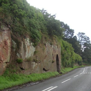
Take a look next time you walk along the Brownhill and
imagine the number of, largely local, men, wheelbarrow and the muscle power it
must have taken to carve our road through the rock and build the retaining wall
on the other side. The original road
from the ford in the River Perry to the village was over the Brownhill
Quillets, the Medieval strips which were the equivalent of allotments for
villagers to feed their families, and down the hollow way to Five Ways.
The story of the Burlton to Llanymynech Turnpike is
told in some detail in my book, `Ruyton XI Towns – Unusual Name, Unusual
History`.
The Church Bank cutting was almost certainly part of
the Burlton to Llanymynech Turnpike. A
1788 painting shows the road from the River to Church Street went along the
wall beside the graveyard and down the present footpath to the bottom of
Gooseberry Lane. Gooseberry Lane was the inner bailey castle ditch.
In 1791 the Platt Bridge was opened, replacing the
ford, just below the bridge. It was
built by local builder, Edward Cureton but the design was passed by the county
surveyor, Thomas Telford.
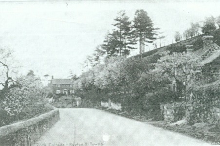
There was another road from the river which went
through a hollow way behind Oak Tree Cottage, Willow View and Glen View,
crossing our road at the bottom of the drive to Rock House and High Bank, then
down to Hockley Hole, at the bottom of the lane opposite the junction with
Little Ness Road. This old road was blocked off by Whitehall Cottage, just up
from the mini roundabout, and Rock Cottage which used to be across what is now
the drive to the two new houses. Both cottages
were strategically built across the road, making sure everyone knew the old
road was closed.
By 1840 the trustees of the Burlton to Llanymynech
Turnpike were in a panic, the Brownhill part of the road was in a parlous
state, “the crust is reduced to a great thinness and, therefore weakness
will, if not speedily amended, terminate in disruption.” Insufficient funds
could be raised to maintain the road so a 5th tollhouse was built
just over the Platt Bridge.
With the new and improved roads, the network of stage
coaches, which travelled in stages and also carried the post, began to
improve and coaching inns were opened where travellers could get a meal and a
bed, and horses could be changed after
as little as 8 miles of fast galloping.
One great improvement for the passengers` comfort was the invention of
springs on the coaches.
Between 1815 and 1826 Thomas Telford surveyed, planned
and oversaw the building of the first trans Britain road since the Romans, from
London to Holyhead with roads straightened levelled and vastly improved, and a
toll house every 5 miles. No wonder he
acquired the soubriquet, The Colossus of Roads. Telford followed the Roman way
of road building with deep foundations and good drainage which have been shown
to have survived to this day, underneath the modern rubbish which is breaking
up along our local roads.
 |

|
 |
| Hollow Way looking up from New Mills |
Hollow Way looking up from 5 ways to the Brownhill Fields | How the Romans built their roads to last - unlike today |
 |
 |
 |
| The rockface on the Brownhill |
Rock Cottage across the old road - and Damson Blossom |
Rednal Railway Station - alight here for the Fly Boat to Newtown |
 |
||
| Baschurch Station, board here for the seaside |